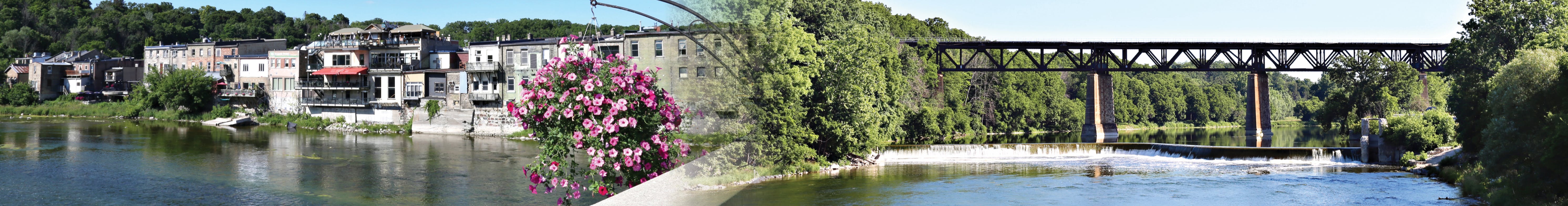
Paris Flood Mitigation Class Environmental Assessment

Share on Facebook Share on Twitter Share on Linkedin Email this link

Construction of the existing Paris flood protection was completed in 1979.

The County of Brant initiated the Paris Flood Risk Mitigation Master Plan to address maintenance and upgrades to the existing flood protection in Paris, Ontario. A condition assessment, completed in April 2019, found that the existing flood protection measures need significant maintenance because they do not meet stability or preliminary flood protection criteria. Ecosystem Recovery Inc. was retained by the County to provide consulting services and assist with the plan.

The plan evaluated a set of alternatives including:

  • do nothing
  • undertake maintenance and repair activities
  • increase level of protection

Construction of the existing Paris flood protection was completed in 1979.

The County of Brant initiated the Paris Flood Risk Mitigation Master Plan to address maintenance and upgrades to the existing flood protection in Paris, Ontario. A condition assessment, completed in April 2019, found that the existing flood protection measures need significant maintenance because they do not meet stability or preliminary flood protection criteria. Ecosystem Recovery Inc. was retained by the County to provide consulting services and assist with the plan.

The plan evaluated a set of alternatives including:

  • do nothing
  • undertake maintenance and repair activities
  • increase level of protection to the 100-year flood event level or
  • increase level of protection to the regulatory event (ex. major hurricane)


The Outcome
It was determined that the preferred solution is to increase the level of protection to the 100-year flood event level and the solution consists of eight (8) individual projects. A strategy has been developed to inform future funding options.

To learn more about the flood prone areas, visit the Flood Area Map. As well, to learn how to prepare for a flood, visit www.brant.ca/EmergencyPlanning.


The Process
The process included public and Indigenous communities’ consultation. Due to the significant public interest and impact of the works in downtown Paris between the William Street bridge and the Grand River Street bridge, it was recommended that this portion of the project undergo further assessment to include additional technical investigations and public and Indigenous communities’ consultation. Public consultation is important for the success of this project.

A virtual public meeting was held on June 21, 2021 from 6:30 pm – 8:00 pm. A recorded presentation was also posted so interested community members can view the information and submit questions ahead of the virtual meeting.

The Plan was also available for review between April 27, 2022 to July 4, 2022. The Plan is available on the right side menu under "Documents - Paris Flood Risk Mitigation Master Plan" and at the Burford and Paris Customer Service Offices.

All information for this project will be posted on this project page.

Engage with us!
Please leave your questions and comments below.

Stay informed

Subscribe for updates and be the first to learn more information about this project. Add your email to the Stay Informed box on this page and click ‘Subscribe’.

Comments and information regarding this Municipal Class Environmental Assessment are being collected in accordance with the Freedom of Information and Protection of Privacy Act (1990). With the exception of personal information, all comments will be included as public input in the Project File Report which will be placed on the public record.

Questions and Comments?

Please leave your questions and comments below.

loader image
Didn't receive confirmation?
Seems like you are already registered, please provide the password. Forgot your password? Create a new one now.
  • Share on Facebook Share on Twitter Share on Linkedin Email this link

    I would like to know the flood plain level expected at Optimist park in a 100 year flood event, taking all the extra added storm drains in consideration and extra rain water flow from doubling the built up area, together with further narrowing the outflow of river water from Paris with the potential expansion of the sewage plant on Race st. The original plans of our house on 38 Creeden st show a floodway elevation of 222.75m (Cohoon Engineering Proposed Residence Part of Block 47 R.P. 492 Town of Paris, DWG 4011-1 Dec 24-02) The foundation was set at 224.0m (T/FND=224.0, BSMT FFE=223.85) In your GIS tool schedule C, the LPRCA regulatory floodplain now intersects the corner of our property and puts the entire house in the floodplain, The level of the corner on the plot is 224.56 on our drawings. Is our house now expected to flood? Due to changes in modelling or expected increase in water flow or expected decrease in water outflow due to the sewage plant blocking the outflow of water?

    SvennoJ asked 7 months ago

    Implementation of the preferred solution in the now finalised Paris Flood Mitigation Schedule “B” Class Environmental Assessment (Class EA) will have no adverse effect of flood elevations in the 100-year event through the study area. It is noted that the public consultation period for the Paris Flood Mitigation Class EA closed in 2021, and the study has been accepted by the relevant agencies. 


    The Grand River Conservation Authority (GRCA) are responsible for establishing the Regulatory and 100-year flood elevations in Paris for the purpose of planning applications. From time to time the GRCA will update their modelling, including but not limited to, adopting new technology or methods to provide a better understanding of potentially complicated flooding conditions, or incorporate improved data such as topographic survey or flow monitoring.


    Should you require more specific information relating to flood elevations at your property, please contact the GRCA

    Thank you,

    C. Brown

    Public Works Technologist

Page last updated: 24 Mar 2024, 07:21 PM