
Paris Flood Mitigation Class Environmental Assessment
Construction of the existing Paris flood protection was completed in 1979.
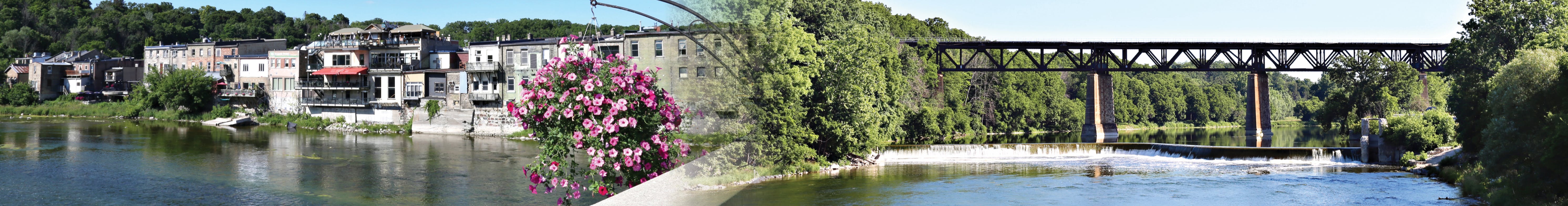
The County of Brant initiated the Paris Flood Risk Mitigation Master Plan to address maintenance and upgrades to the existing flood protection in Paris, Ontario. A condition assessment, completed in April 2019, found that the existing flood protection measures need significant maintenance because they do not meet stability or preliminary flood protection criteria. Ecosystem Recovery Inc. was retained by the County to provide consulting services and assist with the plan.
The plan evaluated a set of alternatives including:
- do nothing
- undertake maintenance and repair activities
- increase level of protectionContinue reading
Page last updated: 10 Feb 2026, 03:52 PM
Videos
-
 Paris Flood Risk Mitigation - Presentation #3
Documents
-
 Press release
-
 Notice of Study Commencement and Public Information Centre No. 1
-
Public Information Centre No. 1 Presentation
-
Flood Mitigation Map.pdf (19.2 MB) (pdf)
-
Public Information Centre Notice #2 - Jan. 14 2020.pdf (145 KB) (pdf)
-
Paris Flood Protection PIC 2 Boards - final.pdf (16.6 MB) (pdf)
-
Public Information Centre #3 - Notice (277 KB) (pdf)
-
Public Information Centre Presentation #3 (5.47 MB) (pdf)
-
Public Information Centre#3 Video Transcript (157 KB) (pdf)
-
Paris Flood Risk Mitigation Masterplan (131 MB) (pdf)
-
Paris Flood Mitigation Masterplan Executive Summary.pdf (419 KB) (pdf)
-
Notice of Study Completion - May 2022.pdf (199 KB) (pdf)


Who's Listening
-
Phone 519-44BRANT (519-442-7268) Email david.mellor@brant.ca -
Phone 519-44BRANT (519-442-7268) Email mark.maxwell@brant.ca -

Phone 519-44BRANT (519-442-7268) Email Clint.Brown@brant.ca


Hello first of all I've lived in St George for abt 22 yrs now and ever since I've moved here I cant believe what i pay for water charges. When I moved in we had a flat rate of about 29$ for 1st meter cubed of water and we had a water meter that wasn't connected. Our bill was coming in ard 45$ a month. We always used our water sparingly. We never had a sewer rate charge all of a sudden its there which has added costs to our bill. Besides the point then came the water meter hook ups. So I got mine connected up figuring my bill would go down well that never happened since no one knew that the billing rate changed and up went our bill again. Every year no matter what our water rates go up always the same reason costs have gone up... So now our taxes are going up almost 9% and for what reason Oh costs have gone up. Now comes some more imagination as to how to get more money out of us by charging a 21$/month flood rate charge?? I've seen just about every rain storm on my street and never once have had a flooded street...It was paid for out of taxes and should remain that way....Its crazy since the pandemic everyone is using the, raise costs and keep going with it Like Trudeau and his crazy tax it govt. We as taxpayers have had enough it has to stop. We had just about no winter this year but nobody is saying oh we saved so much we should rebate us for cost savings. But no in return we get tax increases......When will it STOP
Mr. Brown et al.
We have engaged counsel on the is matter, as you are aware, and all corrospondence must all be sent to them.
DLD, below lays out a good case; to this point we have seen nothing more than engineers drawing lines. While threats of expropriation have been made, these have been vague and without substance, as have the proposals themselves.
The properties on West River street extend to the waterline of the river, and homeowners have kept and maintained the natural ecosystem there for many decades without issue. We will not support any removal of trees and vegetation, nor any pathway.
Hello Mr. Brown,
Please see below for my concerns regarding the proposed flood protection improvements in area N1-3 outline by the County.
Easement
• Proposal needs to be specific. Vague easement proposals will not be approved. The country needs to outline specifications for the easements and its planned use.
• Proposed asphalt path. Path does not add beneficial value for the purpose of flood protection. Easement will not be approved. There are several security and noise concerns with the proposed asphalt path which is slated to pass though residentially owned land.
Tree/vegetation removal.
• No apparent erosion present in area N1-3. What studies were completed to prove substantial and unrepairable erosion of the dike? No data has been provided to the residents of West River Street to support this claim.
• Dikes can harbor many vascular plants that are absent or rare in the surrounding habitats and therefore play a decisive role in maintaining plant diversity. Why has the County proposed to remove them?
• Lime treatment is a well-known technique of earthworks, for soil improvement and stabilization. Were any additional treatment methods considered?
• Vegetation and root systems can act as stabilizers for soil. Removing vegetation will reduce the stability of the bank.
Property Value Concerns
• Removing water access by way of easement will reduce the value of the properties along West River Street.
• Armor stone wall is not acceptable for of flood protection along residential land. They are dangerous (trip and fall hazard) and unappealing. The area should be as naturalized as possible.
Vibration monitoring
• Any drilling, including the use of mobile hollow stem (HSA) auger rigs for geotechnical investigations, would require the County to perform vibratory monitoring at serval locations along the dike and residential properties. HSA rigs use diesel drive pistons to penetrate the soil and bedrock, which can result in damage to nearby foundations. Any bedrock analysis should be carefully monitored as well.
• The shale bedrock is highly fractured. Any drilling will cause damage to the bedrock conditions, resulting in additional pathways to water to travel. Will an analysis of the bedrock be completed to better understand the fractures and how water moves within it?
Species habitat (birds, snakes, salamanders, deer, beaver)
• The dike provides habitat to several species along the Nith River. Any alteration to the dike will result in a negative impact to the flora and fauna.
You stated in the Municipal Class Environmental Assessment that "Direct landowner consultation also occurred in September 2020, including letters to all directly impacted residents, site visits and meeting with various property owners, email and phone correspondence". I have yet to be contacted by a Brant County representative by any of the methods outline above. I'm disappointed in the plan and lack of communication from the County. I would welcome a conversation to further discuss my concerns.
I look forward to addressing these topics during the meeting on June 21st, 2021.
We've been told the plan is to raise the river bank at our property by 6ft and also to raise the bridge by 3 feet but is it necessary to go that high? The last flood was in 1974 and since the completion of the overflows and Dam systems there has been no real concern. When the riverbank cages were installed the area was totally neglected & an eyesore with weeds 4 feet tall. We took care of it, adding thousands of dollars in plants, trees & landscaping. We've put in hard work & time, tons of quartz & granite from around Georgian Bay, Quebec and the kawarthas was all collected & brought here by us. We feel that if you put your wall 6 feet high you will need to have such a large amount of backfill that it will impede on us too much and we will lose a substantial amount of space which will make it not possible to have it replaced as has been suggested would happen. After much thought and careful consideration we feel we would not be able to comfortably agree with the plan at six feet since not only will we be losing a lot of beautiful rock gardens, mature trees, plants & space but our riverview will not exsist at all anymore decreasing property value. Then there will also be the construction aspect of it all with the daily disruptions & constant grind of machinery & early morning driving in and out of our property. With the twinning project there was a lot of disruptions for us & it didn't end well for us in the end since we are still in the process of suing energy + for damages. We've not been shown any definite designs or plans on paper there's been no talk of any kind of compensation for our losses so at this point we can't agree to anything.
I have taken the time to get informed about the said plan through County resources. While it is currently in the works, I appreciate that you are all taking the public feedback into consideration. Safety and wellbeing is certainly, and understandably, a top priority. Therefore, I am not going to say I am opposed to your plans outlined in the video, but the draft, especially for GW2, must take into consideration Paris’ architecture. The buildings are certainly unique compared to other towns in this region. If the town itself could speak, I imagine that Paris would find the thought of losing its historic aspects saddening. While to the aim here is to preserve these buildings from water damage, the heritage appeal that they embody runs the risk of being diminished. Old structures on rivers and other water bodies have survived in Europe for centuries with proper maintenance. Therefore, I hope that local businesses, especially restaurants that have low lying balconies on the ground floor will be able to benefit from safety without detriment to their views or use of property and even the integrity of their foundations. As well, the trees and wildlife should not be impeded in the process, and if so, it is a controlled amount with the opportunity to replant and regrow.
I am wondering if an alternative draft can be considered for the reinforcement against the downtown buildings (GW2 draft), such as improved dyke or redirective structures upriver that could be implemented. I have some resources below from the Netherlands. The Dutch are used to living in floodplains and have engineered various mitigation plans over the years that, I believe, our engineers should look to for inspiration. Perhaps taking on a project in this style, albeit on a smaller scale, would reduce the need for altering and only doing necessary repairs on Paris’ building foundations. I look forward to being informed about the plan as it progresses and that everyone in the community will feel confident and satisfied with the final draft.
Some links to resources
Rijkswaterstaat: Ministry of Infrastructure and Water Management - Maeslantkering
https://www.rijkswaterstaat.nl/english/about-us/gems-of-rijkswaterstaat/maeslant-barrier/index.aspx
Port of Rotterdam: Sluiting Maeslantkering - Infographic
https://www.portofrotterdam.com/nl/havenkrant/havenkrant-online-extra/sluiting-maeslantkering
Rijkswaterstaat: Ministry of Infrastructure and Water Management https://www.rijkswaterstaat.nl/english/about-us/gems-of-rijkswaterstaat/houtribdijk-reinforcement/index.aspx
https://e360.yale.edu/features/to_control_floods_the_dutch_turn_to_nature_for_inspiration
Removed by moderator.
I hope the county is seeking the least expensive and least invasive actions.
Paris is an historic community whose beauty attracts tourists from all over the world. The view of the heritage buildings along the Grand is iconic. It is representative of our town and should be preserved.
A Royal Commision made recommendations after the 1976 flood to help mitigate future flooding. Those recommendations were implemented. There has not been any significant flooding in Paris since.
It seems somewhat over zealous to spend a large amount of public money, and destroy a heritage site that has been instrumental in giving our town the designation of Prettiest little Town in Ontario, in order to theoretically prevent the possibility of a future flood.
These buildings and this town have stood on the Grand for a long time. The slim possibility of a 'once in a century' flood seems like a poor excuse to spend millions of dollars destroying our heritage.