Oakland Trail and Wildlife Observation Deck

The County of Brant is exploring a new way to connect with nature in Oakland through the development of a nature trail and wildlife observation deck at Smith Mill Pond.

The proposed project would give residents another place to walk, enjoy the outdoors and experience the natural environment close to home.

The project is in the early design stage and has been included in the County's 2026 budget. Before the design is finalized, we want to hear from the community about the proposed concept and what should be considered as the project moves forward.

What is being proposed?

The proposed 370 metre trail would follow a section of the former Lake Erie and Northern Railway corridor through an area that is currently farmed and leads to Smith Mill Pond.
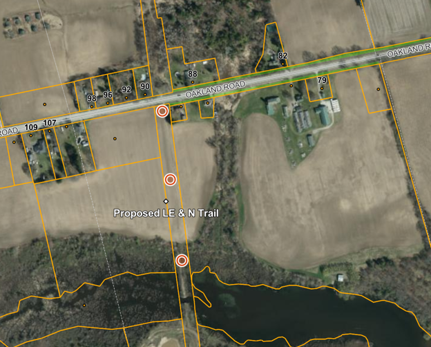
At the pond, a new wooden observation deck would provide a place to stop, enjoy the view, and observe local wildlife.

The current concept includes:

  • A stone dust trail surface
  • A wooden observation deck overlooking Smith Mill Pond
  • Entry and wayfinding signage
  • Interpretive signage highlighting the area's natural features and railway history
  • Limited parking, with additional on-street parking available nearby

View the draft concept design.

Planning and engagement

As the project develops, the County is considering the natural environment, local history and feedback from the community and Indigenous Partners.

We are reaching out to Indigenous Partners to share information about the proposed project and invite their feedback. Any feedback received will be considered as the project design develops.

Potential impacts on wildlife and habitat are also being considered as part of the project's planning and design. We are consulting with the Grand River Conservation Authority (GRCA), and any required permits or approvals will be identified and applied for at the appropriate stage of the project.
Why that location?

The County currently maintains the LE & N Trail between Brantford and Mt. Pleasant. The former rail corridor also extends through Oakland, where it crosses farmed fields near the eastern edge of the village and ends at Smith Mill Pond.

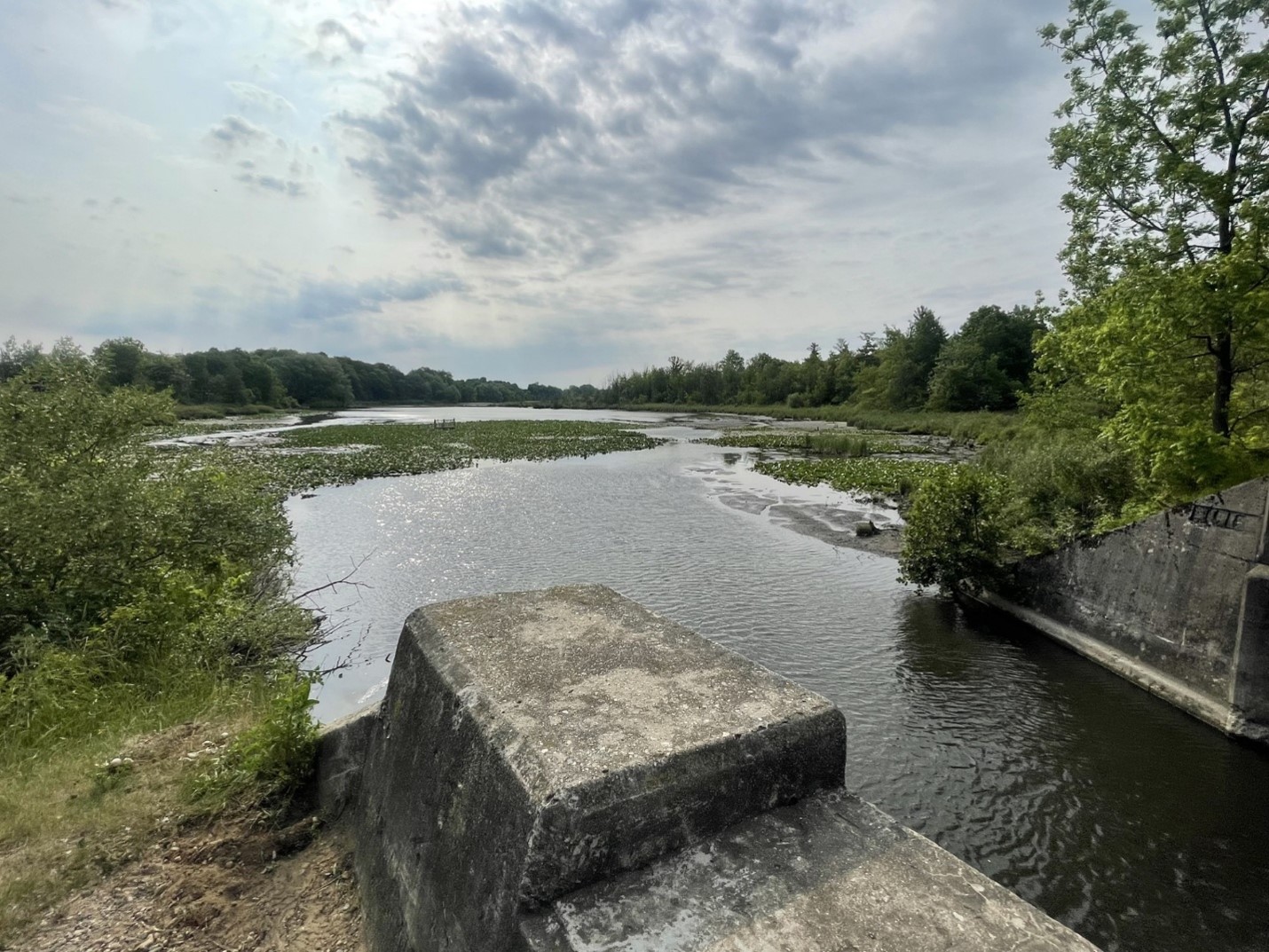
The railway once continued south across a bridge at the pond. While the bridge no longer exists, one of the original bridge abutments will be incorporated into the proposed observation deck. Interpretive information would also help tell the story of the former railway route.

There are no plans to construct a new bridge or extend the trail across the pond to Jenkins Road.

A new trail in this location was identified in the County's 2017 Trails Master Plan. The proposed project presents an opportunity to create a unique section of trail in Oakland and provide greater local access to nature and Smith Mill Pond.

Read a full list of FAQs.


Stay informed

Updates and announcements will be posted on this page. Subscribe to receive updates by adding your email to the Stay Informed box on this page and click ‘Subscribe'.

The County of Brant is exploring a new way to connect with nature in Oakland through the development of a nature trail and wildlife observation deck at Smith Mill Pond.

The proposed project would give residents another place to walk, enjoy the outdoors and experience the natural environment close to home.

The project is in the early design stage and has been included in the County's 2026 budget. Before the design is finalized, we want to hear from the community about the proposed concept and what should be considered as the project moves forward.

What is being proposed?

The proposed 370 metre trail would follow a section of the former Lake Erie and Northern Railway corridor through an area that is currently farmed and leads to Smith Mill Pond.

At the pond, a new wooden observation deck would provide a place to stop, enjoy the view, and observe local wildlife.

The current concept includes:

  • A stone dust trail surface
  • A wooden observation deck overlooking Smith Mill Pond
  • Entry and wayfinding signage
  • Interpretive signage highlighting the area's natural features and railway history
  • Limited parking, with additional on-street parking available nearby

View the draft concept design.

Planning and engagement

As the project develops, the County is considering the natural environment, local history and feedback from the community and Indigenous Partners.

We are reaching out to Indigenous Partners to share information about the proposed project and invite their feedback. Any feedback received will be considered as the project design develops.

Potential impacts on wildlife and habitat are also being considered as part of the project's planning and design. We are consulting with the Grand River Conservation Authority (GRCA), and any required permits or approvals will be identified and applied for at the appropriate stage of the project.

Why that location?

The County currently maintains the LE & N Trail between Brantford and Mt. Pleasant. The former rail corridor also extends through Oakland, where it crosses farmed fields near the eastern edge of the village and ends at Smith Mill Pond.

The railway once continued south across a bridge at the pond. While the bridge no longer exists, one of the original bridge abutments will be incorporated into the proposed observation deck. Interpretive information would also help tell the story of the former railway route.

There are no plans to construct a new bridge or extend the trail across the pond to Jenkins Road.

A new trail in this location was identified in the County's 2017 Trails Master Plan. The proposed project presents an opportunity to create a unique section of trail in Oakland and provide greater local access to nature and Smith Mill Pond.

Read a full list of FAQs.


Stay informed

Updates and announcements will be posted on this page. Subscribe to receive updates by adding your email to the Stay Informed box on this page and click ‘Subscribe'.

Questions and comments

County of Brant Staff aim to maintain a respectful and constructive dialogue through all forms of communication. We understand and appreciate that people have differing opinions and concerns, and welcome all feedback in a respectful and constructive manner.

Please ask your question or leave your comment below. We will do our best to respond within 3 business days.

You may also find answers to your questions by visiting our list of FAQs.

Email
loader image
Didn't receive confirmation?
Seems like you are already registered, please provide the password. Forgot your password? Create a new one now.
  • How are investments in new trails prioritized / recommended for further development? What metrics or criteria are being used to reflect on the project's success?

    Erik Hager asked 2 months ago

    Thank you for your questions. The proposed Oakland Trail was identified in the County’s 2017 Trail Master Plan as an opportunity to use a former rail corridor to create a recreational trail and provide access to nature.


    When considering new trails, the County looks at several factors, including:


    • Opportunities to connect existing trails or fill gaps in the network
    • Pedestrian safety and active transportation needs
    • Population and community needs
    • Connections to destinations
    • Recreational value
    • Available land or existing corridors
    • Opportunities to work with landowners, organizations, and other public agencies


    In rural and urban areas, opportunities for new trails also depend on whether suitable land is available. This can include former rail corridors, County owned land, land secured through development, or partnerships with other landowners and organizations.


    Once a trail is built, trail counters help us understand how much it’s being used and help guide maintenance needs. We also gather feedback from residents and visitors through recreation planning processes to better understand satisfaction with trails and other recreational facilities.


    For the proposed Oakland Trail, community feedback gathered through this engagement will also help us better understand local interest, potential uses, concerns, and other considerations before the project moves forward.


    For more information about County of Brant trails, please visit brant.ca/trails.

Page last updated: 14 Oct 2026, 03:33 PM